Historical News
Water Column Clarity
Water Column Profiles
Water column profiles were measured at seven sites in the Providence and Seekonk Rivers on July 15, 2020. The NBC's Seabird profiling instrument was sent to the manufacturer for routine servicing over the winter; due to the COVID-19 pandemic, the return of the instrument has been greatly delayed. In the absence of this instrument, the NBC Environmental Monitors utilized a YSI EXO sonde to collect data on surface and bottom conditions at seven typical Seabird sites on July 15. Settings on this instrument were not optimized for measurements of a true profile, rather the goal was stable estimates of conditions at the surface and bottom only. These data are summarized here, and raw data are available upon request. The three days prior to the survey date were moderately wet, with approximately 0.82 inches of total rainfall recorded. Evidence of salinity stratification was observed at all sites; the strongest stratification was observed at Phillipsdale Landing (bottom salinity 12 ppt > surface), while the weakest was observed at Edgewood Yacht Club (bottom salinity 4 ppt > surface).
Estimated surface salinities were highest at Pomham Rocks and Edgewood Yacht Club (25 ppt), and lowest at Phillipsdale Landing (15 ppt). The highest estimated bottom salinity (31 ppt) was observed at Conimicut Point and Bullock Reach, while the lowest (27 ppt) was observed at Phillipsdale Landing. The warmest waters overall were observed at Pawtuxet Cove, from approximately 26.3°C at the surface to 25.2°C at the bottom. The coolest surface waters (23.8°C) were observed at India Point Park, while the coolest bottom waters (21.3°C) were observed at Conimicut Point.
Dissolved oxygen (DO) concentrations were low at most sites this week. Hypoxic (i.e., DO <2.9 mg/L) conditions were observed at the bottom waters of all sites except for Bullock Reach and Conimicut Point. Surface DO ranged from 3 to 7 mg/L across all sites. The estimated surface chlorophyll averaged 27.6 ug/L among all sites, with a maximum of 100.8 ug/L observed at Conimicut Point.
Bacteria Sampling
The geometric mean of fecal coliform results for all sites was 13 MPN/100 mL; counts were higher at the Seekonk River sites than the Providence River sites (geometric means of 58 MPN/100 mL and 6 MPN/100 mL, respectively). The maximum count (2300 MPN/100 mL) was measured at Division St. Dock. Results from the Providence River were within the state standards for primary contact and shellfishing, however, results from the Seekonk River exceeded these state standards.
The enterococci results decreased slightly from the previous sampling event, from an overall geomean of 16 MPN/100 mL to 14 MPN/100 mL. Enterococci results ranged from <10 MPN/100 mL measured at four sites (Phillipsdale Landing, South FP East, Gaspee Point, and Conimicut Point) to 86 MPN/100 mL at Point St. Bridge. These enterococci results were within the state standards for primary contact.
Please note: the results of NBC's fecal coliform and enterococci monitoring are for informational/research purposes only and are not intended to suggest official state compliance with bathing or shellfishing standards.
R/V Monitor's Blog
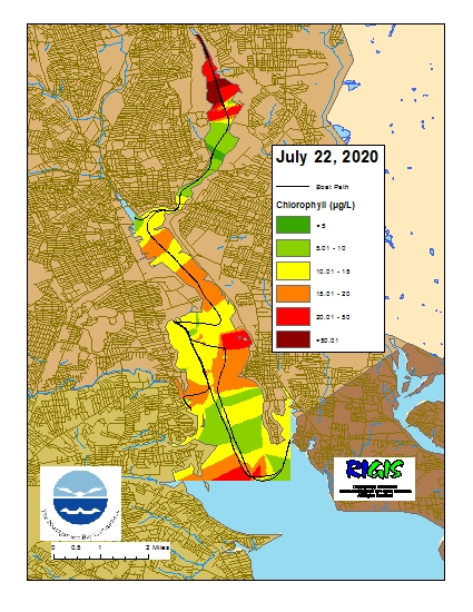
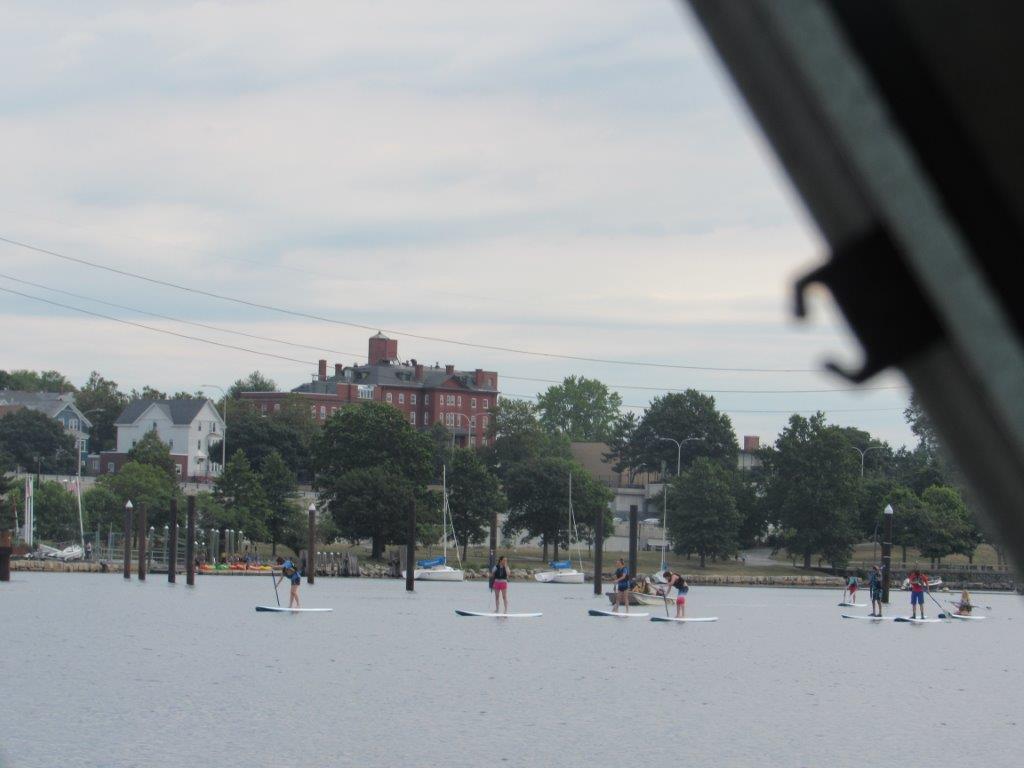
On Wednesday, July 22nd, the crew of the R/V Monitor was out on the upper Bay collecting bacteria samples, taking Secchi Disk water clarity measurements, conducting water column profiles using a profiling sonde, and conducting real-time surface mapping of water quality parameters, including dissolved oxygen, chlorophyll, water temperature, salinity, and pH, all in an effort to document water quality improvements associated with NBC construction projects. The crew also changed out the sonde at the temporary buoy at Pawtuxet Cove and collected a chlorophyll sample while there. Sara captained the boat while monitoring professionals Fern and Mike collected the samples and data. The day began cloudy but cleared by the afternoon. There was a slight breeze all day but the water remained calm. This day's featured photo was taken at India Point Park of paddle boarders.
Surface Mapping
Data
were collected on July 22, 2020 while the R/V Monitor was underway collecting bacteria
samples in the Providence and Seekonk River estuaries. The chlorophyll concentrations
were highly variable ranging from good to poor. From north to south, average
chlorophyll concentrations were as follows: Seekonk River (24.79 µg/L), Upper
Providence River (15.25 µg/L), Edgewood Shoals area (11.97 µg/L), Pawtuxet
River area (13.34 µg/L ), and Lower Providence River area (12.55 µg/L ).
Overall, chlorophyll ranged between non-detectable and 186.10 µg/L with an
overall average of 17.31 µg/L. The chlorophyll data from this date are
presented in the map below: