Historical News
R/V Monitor's Blog
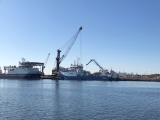
The R/V Monitor was out on the upper Bay twice this week. First, on Tuesday, November 3rd, the crew was out servicing NBC's Bullock's Reach buoy. Sondes were swapped out with freshley calibrated sondes. Sara captained the boat while monitoring professionals Steve and Mike serviced the buoy. It was a cloudy, cold and breezy day with the wind out of the west-northwest. On Wednesday, November 4th, the crew was out collecting nutrients and plankton samples, taking Secchi Disk and Par sensor water clarity measurements, conducting water column profiles using the Seabird instrument, and conducting real-time surface mapping of water quality parameters including dissolved oxygen, chlorophyll, water temperature, salinity, and pH, all in an effort to document water quality improvements associated with NBC construction projects. In the afternoon, the crew visited the Bullock's Reach buoy to change out a sonde that was discovered to be tangled the prior day. Sara captained the boat in the morning and Jeff in the afternoon while monitoring professionals Fern, Steve and Mike collected the samples and data. The day was sunny and brisk, with no wind in the morning but picking up out of the south by the afternoon. The featured photo from this day is of cargo ships observed at ProvPort.
Water Column Profiles
Water column profiles were measured at eight sites in the Seekonk and Providence Rivers on September 23, 2020. Weather leading up to the survey was dry, with no rainfall recorded over the five days prior. Minor density stratification was observed at Phillipsdale Landing, though all other sites were mostly well-mixed. Water temperatures were coolest at Bullock Reach and Conimicut Point, around 17°C at the surface, with a minimum temperature reading of 16.2°C near the bottom at Conimicut Point. The warmest waters were observed at India Point Park, 19°C at the surface and 18°C at the bottom; note that this site was surveyed in the afternoon, and it was a hot day, likely confounding our comparisons of water temperatures across sites. Surface salinities were lowest at Phillipsdale Landing, around 23 psu, and ranged up to a maximum of 29.9 psu at Conimicut Point. Bottom salinities were highest at Conimicut Point and Bullock Reach, at 31 psu. Dissolved oxygen (DO) concentrations were fair to good at most sites, with all waters remaining above the hypoxia threshold (2.9 mg/L DO). The lowest DO this week was observed about a meter off the bottom at India Point Park, at 3.9 mg/L. Fluorescence data suggest only minor phytoplankton activity at Phillipsdale, even less at remaining sites. Due to a QC issue, numerical fluorescence data are not posted at this time.
Water Column Profiles
Water column profiles were measured at eight sites in the Seekonk and Providence Rivers on September 16, 2020. Weather leading up to the survey was dry, with no rainfall recorded over the five days prior. Minor density stratification was observed at Phillipsdale Landing, though all other sites were mostly well-mixed. As the change from summer to fall is underway, surface temperatures were colder than bottom temperatures at many sites. Surface waters ranged from 19.6°C at Bullock Reach to 23°C at Point St. Bridge. Bottom temperatures were also 23°C at Point St. Bridge, while the coolest bottom waters occurred at Pomham Rocks (20.5°C). Surface salinities were lowest at Pawtuxet Cove and Phillipsdale Landing, in the low 20 ppt range. Surface salinites at other sites ranged up to a maximum of 30.5 psu at Conimicut Point. Bottom salinities were also highest at Conimicut Point (30.9 psu), and lowest at Phillipsdale Landing (28.3 psu). Dissolved oxygen (DO) concentrations were fair at most sites, except for India Point Park and Point St. Bridge. Waters at these sites were hypoxic (<2.9 mg/L DO) below 5.5 meters and 4 meters, respectively. Fluorescence data suggest only minor phytoplankton activity at Phillipsdale, even less at remaining sites. Due to a QC issue, numerical fluorescence data are not posted at this time.
Water Column Profiles
Nutrients Sampling

