Historical News
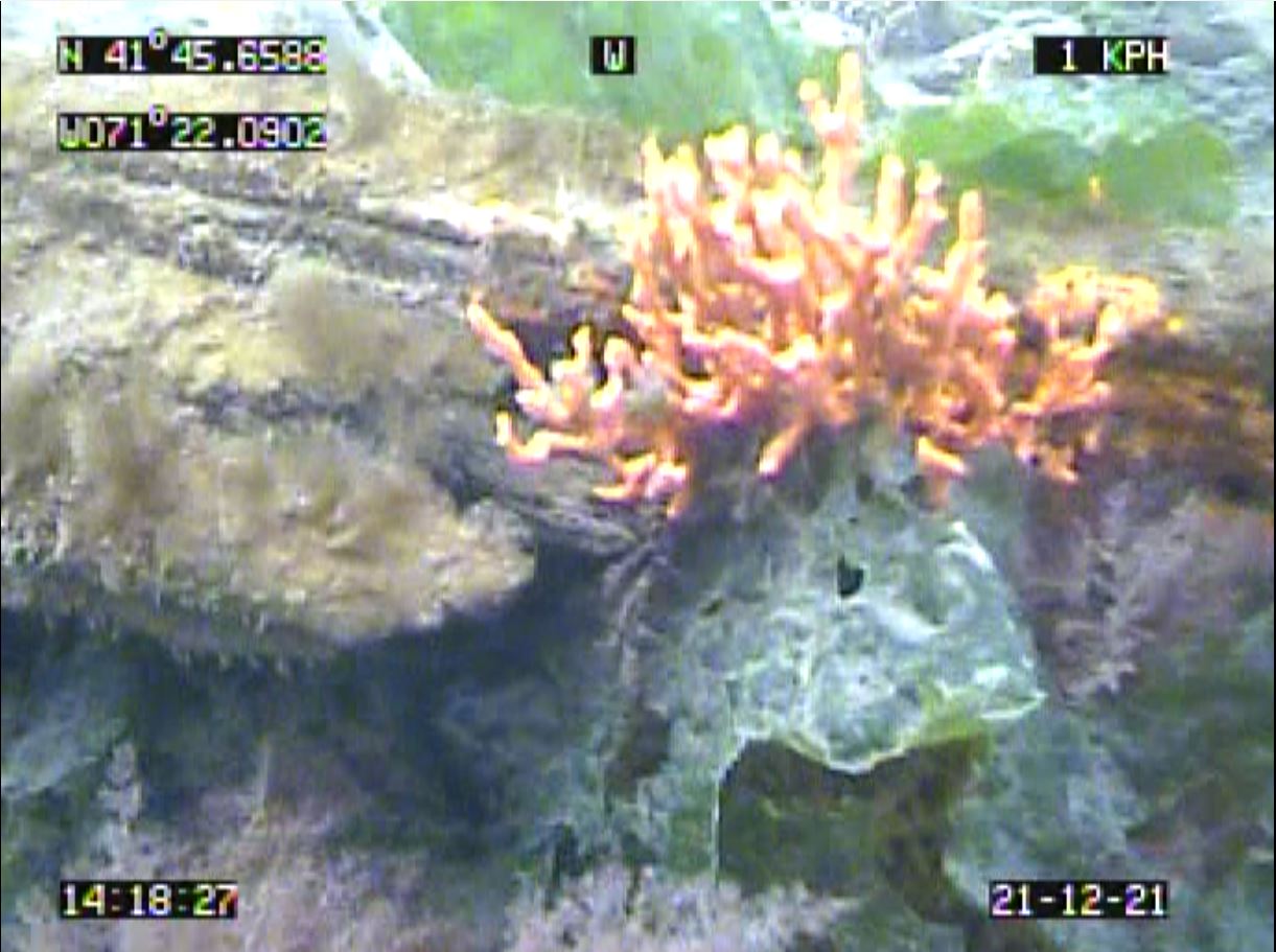
Benthic Video Blog
The boat crew conducted benthic video surveys along the Sabin and Edgewood transect locations on December 21, 2021. Scale lasers were used in the footage, separated by 29 cm. Visibility through the water column was moderate to good.
Fixed Site Network
Phillipsdale Landing
Overall, water quality at this site was good this week. Conditions this week were mostly dry, with 0.27 inches of rainfall recorded at T.F. Green. Generally, Blackstone River flows were similar to the previous week while remaining elevated over historical median levels. Surface salinity increased from the previous week, averaging 5.4 ppt with a maximum value of 11.4 ppt. Bottom salinity averaged 15.2 ppt and a maximum value of 29.1 ppt. Water temperatures averaged 7.7°C on the surface and 10.6°C on the bottom. Temperatures ranged from 5.1°C to 10.7°C at the surface and from 6.1°C to 12.9°C at the bottom.
Dissolved oxygen (DO) remained well above the hypoxia threshold (DO ≤ 2.9 mg/L) this week. Surface DO averaged 10.8 mg/L, with a minimum of 9.1 mg/L, while bottom DO averaged 8.3 mg/L, with a minimum of 6.7 mg/L. In general, chlorophyll concentrations decreased slightly from the previous week, averaging 0.9 ug/L at the surface and 1.3 ug/L at the bottom, with a surface maximum of 1.8 ug/L. Please note that tidal fluctuations and Blackstone River flows greatly influence water column salinity, temperature, and DO at this location.
Bullock Reach
The Bullock Reach sondes were removed for the 2021 monitoring season on November 18.
Fixed Site Network
Phillipsdale Landing
Phillipsdale Landing sondes were changed out for routine maintenance during the morning of November 16. Overall, water quality at this site was good this week. Conditions this week were mostly dry, with 0.21 inches of rainfall recorded at T.F. Green. Blackstone river flows decreased through the week, impacting surface and bottom salinity concentrations at this site. In response to the mostly dry conditions, surface salinity increased through the week, averaging 3.5 ppt with a maximum value of 12.1 ppt. Bottom salinity averaged 13.3 ppt, with a maximum value of 27.8 ppt. Water temperatures averaged 9.4°C on the surface and 11.3°C on the bottom. Temperatures ranged from 6.8°C to 10.7°C at the surface and from 8.4°C to 13.6°C at the bottom.
Dissolved oxygen (DO) remained well above the hypoxia threshold (DO ≤ 2.9 mg/L) this week. Surface DO averaged 10.8 mg/L, with a minimum of 9.3 mg/L, while bottom DO averaged 8.7 mg/L, with a minimum of 5.6 mg/L. In general, chlorophyll concentrations were similar to the previous week, averaging 1.5 ug/L at the surface and 1.5 ug/L at the bottom, with a surface maximum value of 2.5 ug/L. Please note that tidal fluctuations and Blackstone River flow greatly influence water column salinity, temperature, and DO at this location.
Bullock Reach Buoy
The Bullock Reach sondes were removed for the 2021 monitoring season on November 18 and data collected from the sondes before they were removed are included in this summary. Please note that the mid-sonde data are not reported in this summary due to a malfunction of the C/T sensor. Water quality was good this week at this site. Surface salinity averaged 24.2 ppt and ranged from 19.7 ppt to 27.5 ppt, while bottom waters averaged 30.1 ppt and ranged from 28.1 ppt to 31.5 ppt. Temperatures averaged 12.3°C at the surface and 13.5°C at the bottom. Surface temperatures ranged from 11.0°C to 13.3°C while bottom temperatures ranged from 11.8°C to 13.8°C.
Dissolved oxygen (DO) concentrations remained above the hypoxia threshold (DO ≤ 2.9 mg/L) throughout the water column. Surface Do averaged 8.1 mg/L, while bottom DO averaged 7.4 mg/L, with a minimum of 6.9 mg/L. Chlorophyll concentrations were low at all depths this week, averaging 1.3 ug/L at the surface and 1.5 ug/L in bottom waters. The maximum water column chlorophyll concentration was 3.9 ug/L, measured at the bottom on November 15.
Fixed Site Network
Phillipsdale Landing
Overall, water quality at this site was good this week. Note that a large portion of the surface data on November 13 were deemed suspect due to the surface sonde being too shallow. Additionally, portions of bottom data on November 08 were also flagged due to the bottom sonde having battery issues as well as on November 13 due to the sonde being too shallow. All flagged surface and bottom data were excluded from the summary below. Rainfall totaled 1.82 inches at TF Green, with all the rainfall occurring on the last two days of the week. Impacted by the heavy rainfall at the end of the week, Blackstone River flows increased as the week progressed while remaining elevated over historical median levels. Surface salinity decreased as Blackstone River flows increased, averaging 6.7 ppt with a maximum value of 16.3 ppt. Bottom salinity averaged 15.5 ppt and a maximum value of 28.1 ppt. Water temperatures averaged 11.1°C on the surface and 13.2°C on the bottom. Temperatures ranged from 9.1°C at the surface and from 10.9°C to 14.9°C at the bottom.
Dissolved oxygen (DO) remained well above the hypoxia threshold (DO ≤ 2.9 mg/L) this week. Surface DO averaged 9.7 mg/L, with a minimum of 7.7 mg/L, while bottom DO averaged 6.6 mg/L, with a minimum of 4.9 mg/L. In general, chlorophyll concentrations decreased slightly from the previous week, averaging 1.5 ug/L at the surface and 0.9 ug/L at the bottom, with a surface maximum of 5.0 ug/L. Please note that tidal fluctuations and Blackstone River flows greatly influence water column salinity, temperature, and DO at this location.
Bullock Reach Buoy
Note that due to a malfunction of the C/T sensor in both the middle and bottom sondes, all the middle depth data this week and portions of bottom depth data on November 13 were deemed suspect and were excluded from the following summary. Overall, water quality at this site was good this week. Generally, salinity decreased slightly over the course of the week, averaging 25.6 ppt at the surface and 30.3 ppt in bottom waters. Lowest salinity (21.3 ppt) occurred in surface waters, while greatest salinity (31.4 ppt) occurred in bottom waters. Temperatures averaged 14.5°C at the surface and 15.8°C at the bottom. Surface temperatures ranged from 11.9°C to 14.6°C and bottom temperatures ranged from 13.7°C to 15.0°C.
This week, DO averaged 7.6 mg/L at the surface and 6.9 mg/L at the bottom. Hypoxic conditions (DO ≤ 2.9 mg/L) were not observed at any depths this week. The minimum DO value (6.3 mg/L) occurred in bottom waters in the early morning of November 2. Chlorophyll concentrations averaged 1.6 ug/L at the surface with a maximum chlorophyl value of 3.7 ug/L.
Nutrients Sampling
Nutrient samples were collected from seven local river stations and surface waters of five bay stations on November 17, 2021. Bay sampling remains limited due to mechanical issues with the NBC’s research vessel, the R/V Monitor. In the five days prior to sampling, rainfall totaled 1.86 inches at T.F. Green, with the majority of this rainfall occurring on November 12, 2021 (approximately 1.5 inches).
Among the river sites sampled, total nitrogen (TN) and total dissolved nitrogen (TDN) concentrations were highest at the Ten Mile River at Roger Williams Ave. site, measuring 1,130 ppb and 1,150 ppb, respectively. Dissolved inorganic nitrogen (DIN) was greatest (757.2 ppb) at Pawtuxet River at Broad St. The lowest TN, TDN, and DIN values were measured at the Moshassuck River at Higginson Ave. site, with results of 540 ppb, 507 ppb, and 273.8 ppb, respectively.
Among the Bay sites, the greatest TN (810 ppb) and TDN (700 ppb) results were measured at the Phillipsdale Landing site. The highest DIN (496 ppb; average of 2 duplicates) occurred at Pawtuxet Cove. The lowest TN and DIN results were measured at Edgewood Shoal (571 ppb and 276 ppb). The lowest TDN value (426 ppb) was measured at Edgewood Yacht Club. Chlorophyll a concentrations were comparable to those measured at the last sampling event, averaging 0.46 µg/L, with a maximum of 0.64 µg/L measured at Edgewood Shoal.
Results from nutrient sampling on December 1, December 15, and December 29 are pending analysis. The next scheduled date of nutrient sampling is January 12.

