Historical News
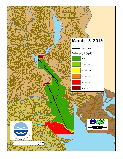
Surface Mapping
Data was collected on March 13, 2019 while the R/V Monitor was underway collecting nutrient samples and performing vertical profiles in the Providence River estuary. The chlorophyll concentrations were low to fair in areas surveyed. From north to south, average chlorophyll concentrations were as follows: Upper Providence River (11.94 µg/l), Edgewood Shoals area (5.09 µg/l), Pawtuxet River area (1.85 µg/l), and the Lower Providence River (29.55 µg/l). Overall, chlorophyll ranged between non-detectable and 137.50 µg/l with an overall average of 16.06 µg/l. The chlorophyll data from this date is presented in the map below:
Bacteria Sampling
Twenty stations were sampled for fecal coliform bacteria in the Providence and Seekonk Rivers on February 6, 2019. Five stations were also sampled for enterococci bacteria. Light rain (0.1 inches of precipitation) occurred the morning of sampling.
Fecal coliform geometric mean decreased from the previous sampling to 17 MPN/100 mL. The fecal coliform geomean was higher in the Seekonk River (29 MPN/100 mL) compared to the Providence River (13 MPN/100 mL). The maximum fecal coliform concentration (430 MPN/100 mL) was measured at Point Street Bridge in the Providence River. Fecal coliform bacteria results in both rivers met state guidelines for primary contact.
The enterococci geometric mean for the Seekonk and Providence Rivers decreased from the previous sampling to 13 MPN/100 mL. Enterococci concentrations ranged from below detection at three stations to 63 MPN/100 mL at Point Street Bridge. These results are within the state criteria for primary contact.
Please note: the results of NBC's fecal coliform and enterococci monitoring are for informational/research purposes only and are not intended to suggest official state compliance with bathing or shellfishing standards.
Water Column Clarity
Water clarity was measured at seven locations in the Providence and Seekonk Rivers on February 6, 2019. Light rain (0.1 inches) occurred on the morning of sampling, but conditions were relatively dry for the five days prior to sampling. Average water clarity decreased from the previous week, from 2.7 m to 2.1 m.
Water clarity increased at Phillipsdale Landing and Point Street Bridge, with the largest increase in clarity (0.6 m) occurring at Point Street Bridge. Water clarity decreased at India Point Park, Edgewood Yacht Club, Bullock Reach, and Conimicut Point. Secchi depth ranged from 1.56 m at Pomham Rocks to 2.50 m at Phillipsdale Landing. There is evidence of a north to south water clarity gradient.
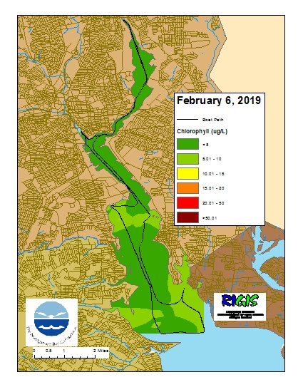
Surface Mapping
Data was collected on February 6, 2019 while the R/V Monitor was underway collecting bacteria samples. The chlorophyll concentrations were low to fair in areas surveyed. From north to south, average chlorophyll concentrations were as follows: Seekonk River (2.02 µg/l), Upper Providence River (3.41 µg/l), Edgewood Shoals area (6.72 µg/l), Pawtuxet River area (3.19 µg/l), and the Lower Providence River (5.42 µg/l). Overall, chlorophyll ranged between 0.50 µg/l and 14.30 µg/l with an overall average of 3.76 µg/l. The chlorophyll data from this date is presented in the map below:
Benthic Video Blog
The boat crew conducted benthic video surveys along the Bullock Reach, Edgewood, and Sabin transects on February 5th. Scale lasers were used in the footage, separated by 29 cm. Visibility through the water column was poor this week at all transects making fine-scale observations impossible. The bottom of all sites was characterized by sands and muds, with occasional boulders and cobbles, as well as sparse to dense shell hash and shell rubble (especially at Sabin). Algal coverage was diverse this week, all sites featured sparse Ulva, filamentous and branching algae (dominate at all transects), as well as sparse sheet-like red algae at Sabin and Bullock Reach; all sites also featured dense areas of diatom felt. General biotic activity was high as noted by extensive tracks and trails. Rare benthic video sights included horseshoe crabs at Sabin and Edgewood (photo below), as well as surfaced chaetopterid tubes at Bullock Reach and Sabin. Infaunal activity was moderate to high; large burrows, likely from mantis shrimp (Squilla), and many small burrows were present. Assemblages of small tube-building fauna and parchment worm (Chaetopterus) tube openings were also common at all sites but more frequent at Bullock Reach and Edgewood. Common observations consisted of Nassariid mudsnails, slipper snail Crepidula (Bullock Reach and Edgewood), ctenophores (all sites), spider crabs (Bullock Reach), hermit crabs (Sabin), and boring sponges (Bullock Reach). All sites also had leaf and stick debris; beverage bottles were also noted at Sabin and Edgewood. Amphipod tube mats were not observed.

