Historical News
Water Column Clarity
Water clarity was measured at eight locations in the Providence and Seekonk Rivers on October 4, 2017. Heavy rains (1.2 inches) fell four days prior to the survey, but the next three days were dry, and overall clarity was improved since the previous week. Secchi depth ranged from 1.8 meters at Pomham Rocks to 2.6 m at Conimicut Point, with an overall average of 2.2 m. The average water clarity was 0.7 m greater than last week, and each site exhibited increased clarity; the greatest increase, 0.9 m, was observed at Phillipsdale Landing. Overall, there was no evidence of a north to south gradient in water clarity this week.
Surface Mapping
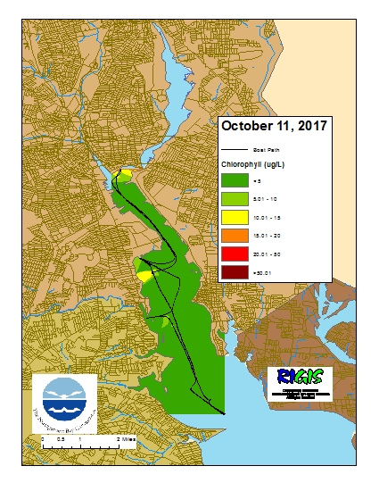
Data was collected on October 11, 2017 while the R/V Monitor was underway collecting nutrient samples and performing vertical profiles in the Providence River estuary. The chlorophyll concentrations were variable with evidence of a north-south gradient. From north to south, average chlorophyll concentrations were as follows: Upper Providence River (10.83 µg/l), Edgewood Shoals area (8.76 µg/l), Pawtuxet River area (3.53 µg/l), and the Lower Providence River (3.17 µg/l). Overall, chlorophyll ranged between non-detectable µg/l and 25.2 µg/l with an overall average of 6.37 µg/l. The chlorophyll data from this date is presented in the map below:
Surface Mapping
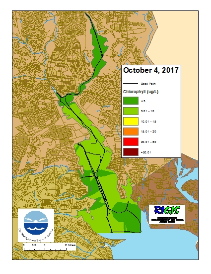
Data was collected on October 4, 2017 while the R/V Monitor was underway collecting bacteria samples and performing vertical profiles in the Providence and Seekonk River estuaries. The chlorophyll concentrations were variable but fair in areas surveyed with 2 of the 5 areas displaying average concentrations below 5 µg/l. From north to south, average chlorophyll concentrations were as follows: Seekonk River (2.95 µg/l), Upper Providence River (5.32 µg/l), Edgewood Shoals area (6.59 µg/l), Pawtuxet River area (4.66 µg/l), and the Lower Providence River (7.68 µg/l). Overall, chlorophyll ranged between 1.00 µg/l and 10.08 µg/l with an overall average of 5.84 µg/l. The chlorophyll data from this date is presented in the map below:
R/V Monitor's Blog
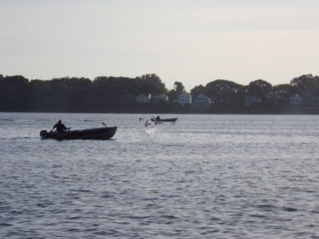
The R/V Monitor was out on the upper Bay twice this week. First, on Tuesday, October 3rd, the crew was out at Bullock's Reach servicing the NBC's buoy. After servicing the YSI sondes back at the NBC, they were all reinstalled on the buoy this day. Jeff captained the boat while monitoring professionals Bekki and Heather performed work on the buoy. It was a warm and sunny day with no breeze and very calm waters. On Wednesday, October 4th, the crew of the R/V Monitor was out on the upper Bay collecting bacteria samples, Secchi Disk and Par sensor water clarity measurements, conducting water column profiles using the Seabird instrument, and conducting real-time surface mapping of water quality parameters, including dissolved oxygen, chlorophyll, water temperature, salinity, and pH, all in an effort to document water quality improvements associated with NBC construction projects. In addition, the hydrocat sondes which had been removed from the Bullock's Reach buoy the prior week for servicing, were redeployed at the buoy in the morning. There was an issue with the mid-depth sonde and it therefore was not redeployed. Jeff captained the boat in the morning while monitoring professionals Sara and Heather collected the samples and data, and redeployed the sondes. Jeff and Sara swapped duties in the afternoon. It was sunny and brisk in the morning, but soon warmed up nicely by the afternoon. There was minimal wind and calm waters all day. There was an issue with the mid-depth sonde and it therefore was not redeployed. It was sunny and brisk in the morning, but soon warmed up nicely by the afternoon. There was minimal wind and calm waters all day. The photo below was taken on October 4th and shows some fishermen enjoying the early fall weather on the upper Bay.
Water Column Clarity
Water clarity was measured at eight locations in the Providence and Seekonk Rivers on September 27, 2017. Less than 0.1 inches of rain fell during the 5 days prior to sampling. Secchi depth ranged from 1.2 meters at Pomham Rocks to 2.0 meters at Bullock Reach, with an overall average of 1.5 meters. The average water clarity was 0.1 meters lower than the previous sampling date. The largest decrease (0.7 meters) was observed at Pomham Rocks. Overall, there was no evidence of a north to south gradient in water clarity.

