Historical News
Water Column Clarity
Water clarity was measured at eight locations in the Providence and Seekonk River estuaries on June 16, 2021. In the three days prior to sampling, 0.53 inches of rainfall occurred at TF Green. Secchi depth averaged 1.3 meters, a decrease of approximately 0.2 meters from the previous survey. Water clarity ranged from 1.0 meter at Pomham Rocks to 1.4 meters at India Point Park, Edgewood Shoal, and Edgewood Yacht Club. A strong gradient of increasing clarity from north to south was not apparent this week.
Surface Mapping
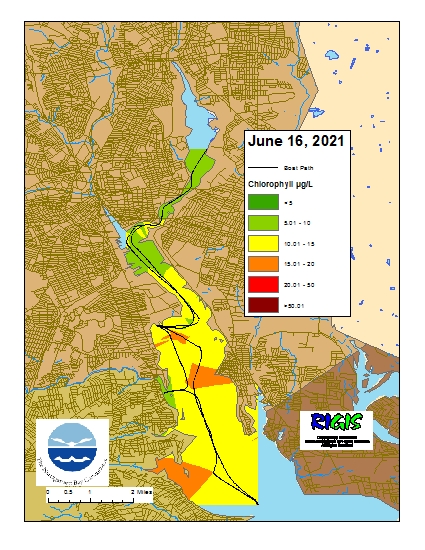
Data were collected on June 16, 2021 while the R/V Monitor was underway collecting nutrient samples in the Seekonk and Providence River estuaries. The average chlorophyll concentrations were fair to poor in the areas surveyed. From north to south, average chlorophyll concentrations were as follows: Seekonk River (7.87 µg/L), Upper Providence River (10.67 µg/L), Edgewood Shoals area (14.81 µg/L), Pawtuxet River area (10.24 µg/L), and Lower Providence River (14.46 µg/L). Overall, chlorophyll ranged between 3.30 µg/L and 22.10 µg/L with an overall average of 11.79 µg/L. The chlorophyll data from this date are presented in the map below:
Water Column Clarity
Water clarity was measured at eight locations in the Providence and Seekonk River estuaries on June 9, 2021. The weather preceding the survey was dry, with no rainfall occurring at TF Green over the three days prior. Secchi depth averaged 1.4 meters, compared to 1.6 meters the week before. The lowest clarity (1.03 meters) was measured at Phillipsdale Landing, while the greatest clarity (1.6 meters) was measured at Point St. Bridge, Bullock Reach, and Conimicut Point. Overall, water clarity generally increased along a down-bay gradient this week.
Surface Mapping
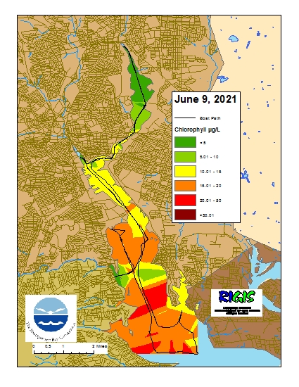
Data were collected on June 9, 2021 while the R/V Monitor was underway collecting bacteria samples in the Seekonk and Providence River estuaries. The average chlorophyll concentrations were good to poor in the areas surveyed. From north to south, average chlorophyll concentrations were as follows: Seekonk River (6.45 µg/L), Upper Providence River (12.04 µg/L), Edgewood Shoals area (16.61 µg/L), Pawtuxet River area (11.56 µg/L), and Lower Providence River (17.92 µg/L). Overall, chlorophyll ranged between 1.28 µg/L and 29.31 µg/L with an overall average of 12.72 µg/L. The chlorophyll data from this date are presented in the map below:
Water Column Clarity
Water clarity was measured at six locations in the Providence River estuary on June 3, 2021. Conditions were relatively dry, with only 0.12 inches of rainfall occurring in the 3 days prior to sampling. Overall, water clarity decreased by 0.5 meters from the previous survey. Secchi depth averaged 1.6 meters, compared to 2.1 meters on May 26, 2021. The lowest clarity (1.4 meters) was measured at Edgewood Yacht Club, while the greatest clarity (2.2 meters) was measured at Conimicut Point. Water clarity increased along a gradient from north to south.
