Historical News
Water Column Clarity
Water clarity was measured at seven locations in the Providence and Seekonk Rivers on June 10, 2020. In the three days prior to the survey there were no recorded precipitation, and water clarity increased compared to the previous survey day. Overall, sites surveyed averaged 2.0 m Secchi depth, compared to 1.79 m on May 28. The lowest clarity was measured at Phillipsdale Landing (1.50 m), while the greatest clarity was measured at Edgewood Yacht Club (2.30 m). Overall, a slight gradient of increasing clarity among the sites from north to south was observed.
Surface Mapping
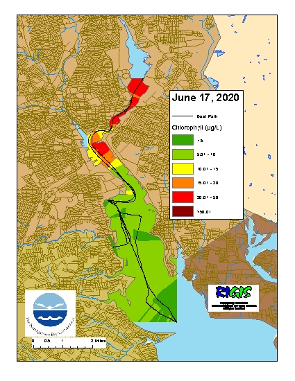
Data were collected on June 17, 2020 while the R/V Monitor was underway collecting nutrient samples in the Providence and Seekonk River estuaries. The chlorophyll concentrations were overall fair with poor conditions in the Seekonk and Upper Providence River. From north to south, average chlorophyll concentrations were as follows: Seekonk River (27.20 µg/L), Upper Providence River (10.95 µg/L), Edgewood Shoals area (6.21 µg/L), Pawtuxet River area (4.97 µg/L ), and Lower Providence River area (5.77 µg/L ). Overall, chlorophyll ranged between 2.10 and 70.60 µg/L with an overall average of 11.88 µg/L. The chlorophyll data from this date are presented in the map below:
Fixed Site Network
Water quality was good this week at Phillipsdale Landing. This week, 0.52 inches of precipitation was recorded, while the previous week was relatively dry (<0.1 inches of precipitation). Average salinity was greater in both surface and bottom waters than the previous week. Surface salinity averaged 15.1 ppt, an increase of 6.5 ppt from the previous week. Surface salinity ranged from 3.0 ppt to 24.3 ppt and increased over the course of the week. Bottom salinity averaged 22.3 ppt and ranged from 8.8 ppt to 28.1 ppt. Surface temperatures were lower than last week, averaging 18.9°C and ranging from 15.2°C to 22.9°C. Bottom temperatures were greater than last week, averaging 16.8°C and ranging from 13.5°C to 21.3°C.
Dissolved oxygen (DO) concentrations have remained above the hypoxia threshold (2.9 mg/L) at both depths. Surface DO averaged 9.7 mg/L, with a minimum of 4.7 mg/L, and bottom DO averaged 6.6 mg/L, with a minimum of 3.9 mg/L. Compared to the previous week, surface chlorophyll increased this week, averaging 24.4 ug/L; readings greater than 50 ug/L were observed intermittently during this deployment period. Note that tidal fluctuations and Blackstone River flow greatly influence water column salinity, temperature, and dissolved oxygen at this location.
Bullock Reach
The Bullock Reach sondes were deployed for the 2020 season on May 22, however equipment troubleshooting is currently underway, and data are not yet suitable for reporting. Data will be posted as soon as possible following authorization by NBC scientists.
R/V Monitor's Blog
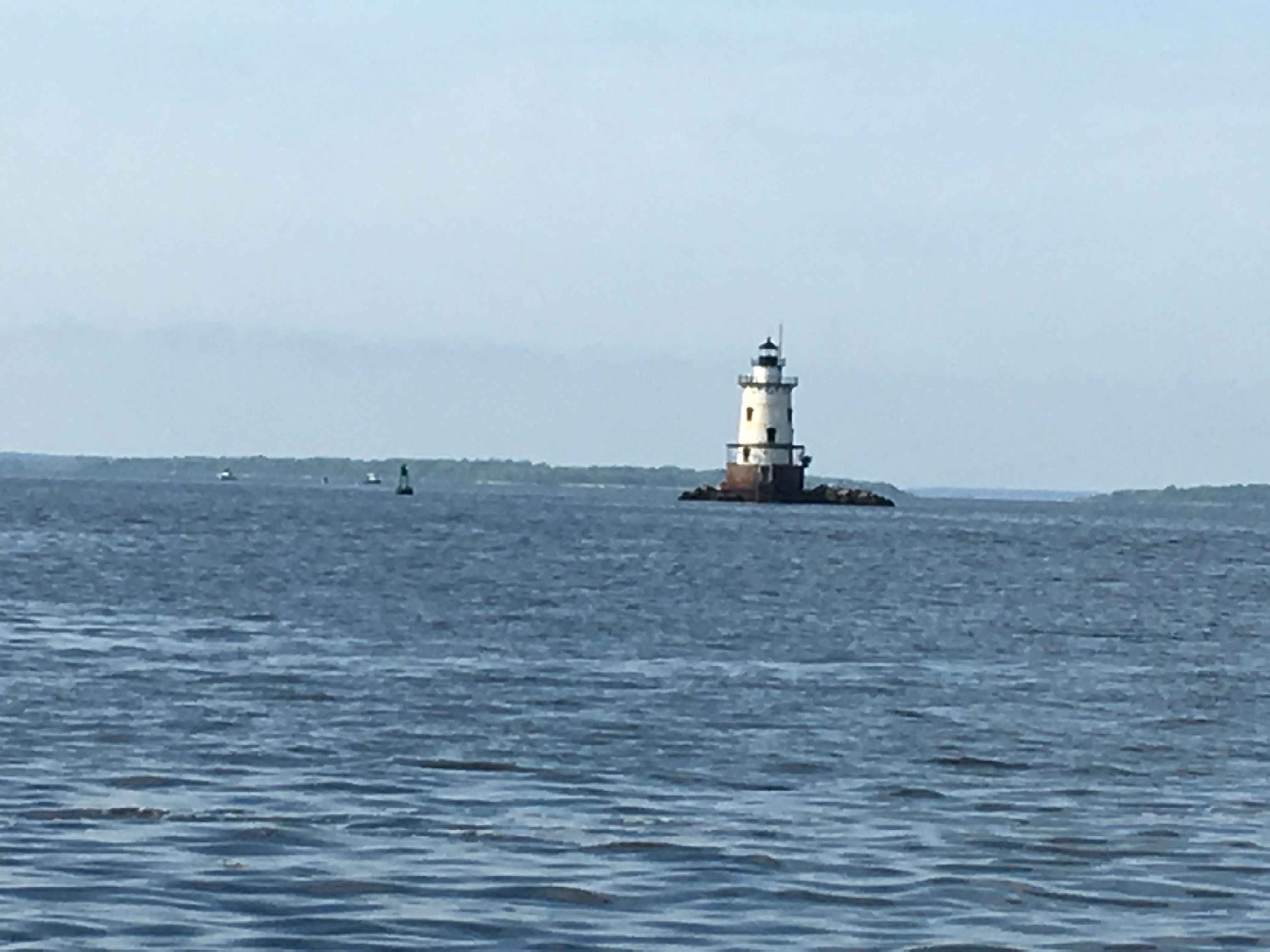
On Wednesday, June 10th, the crew of the R/V Monitor was out on the upper Bay collecting bacteria samples, taking Secchi Disk water clarity measurements, and conducting real-time surface mapping of water quality parameters, including dissolved oxygen, chlorophyll, water temperature, salinity, and pH, all in an effort to document water quality improvements associated with NBC construction projects. Jeff captained the boat while monitoring professionals Michael and Fern collected the samples and data. It was a warm and sunny day with a light variable wind. The featured photo was taken of the Conimicut Lighthouse.
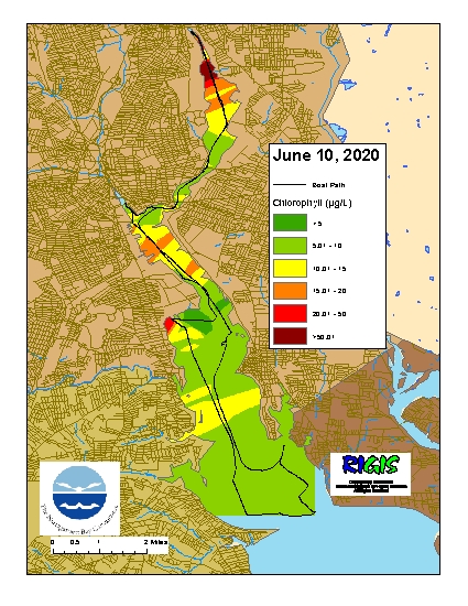
Surface Mapping
Data were collected on June 10, 2020 while the R/V Monitor was underway collecting bacteria samples in the Providence and Seekonk River estuaries. The chlorophyll concentrations were variable and fair. From north to south, average chlorophyll concentrations were as follows: Seekonk River (16.74 µg/L), Upper Providence River (9.33 µg/L), Edgewood Shoals area (9.87 µg/L), Pawtuxet River area (9.83 µg/L ), and Lower Providence River area (7.10 µg/L ). Overall, chlorophyll ranged between 2.00 and 158.00 µg/L with an overall average of 12.15 µg/L. The chlorophyll data from this date are presented in the map below: