Historical News
Fixed Site Network
Phillipsdale Landing
Phillipsdale Landing sondes were changed out for routine maintenance during the mid-day of November 02. Overall, water quality at this site was good this week. Conditions this week were mostly dry, with only 0.34 inches of rainfall recorded at T.F. Green on October 31. Blackstone river flows decreased through the week, impacting surface and bottom salinity concentrations at this site. In response to the mostly dry week, surface salinity increased this week, averaging 5.0 ppt with a maximum value of 16.8 ppt. Bottom salinity averaged 9.8 ppt, with a maximum value of 28.7 ppt. Water temperatures averaged 12.4°C on the surface and 14.1°C on the bottom. Temperatures ranged from 8.8°C to 14.2°C at the surface and from 11.6°C to 16.3°C at the bottom.
Dissolved oxygen (DO) remained well above the hypoxia threshold (2.9 mg/L) this week. Surface DO averaged 9.9 mg/L, with a minimum of 7.7 mg/L, while bottom DO averaged 7.6 mg/L, with a minimum of 5.1 mg/L. In general, chlorophyll concentrations decreased slightly from the previous week, averaging 2.3 ug/L at the surface and 1.2 ug/L at the bottom, with a surface maximum value of 3.5 ug/L. Please note that tidal fluctuations and Blackstone River flow greatly influence water column salinity, temperature, and DO at this location.
Bullock Reach Buoy
Bullock Reach sondes were changed out for routine maintenance during the morning of November 02. Note that due to a malfunction of the C/T sensor in the middle sonde starting in the afternoon of November 4, water quality data at mid-depth following the sensor failure was deemed suspect and was excluded from the following summary. Overall, water quality at Bullock Reach was good this week. Generally, salinity increased slightly over the course of the week, averaging 24.2 ppt at the surface, 30.3 ppt at mid-depth, and 31.0 ppt in bottom waters. Lowest salinity (19.0 ppt) occurred in surface waters, while greatest salinity (32.1 ppt) occurred in bottom waters. Temperatures averaged 14.5°C, 15.9°C, and 15.8°C at the surface, mid, and bottom, respectively. Surface temperatures ranged from 11.1°C to 16.2°C, mid temperatures ranged from 14.6°C to 16.2°C, and bottom temperatures ranged from 14.7°C to 16.3°C.
This week, DO averaged 7.6 mg/L at the surface, 6.6 mg/L at mid-depth, and 6.4 mg/L at the bottom. Hypoxic conditions (DO ≤ 2.9 mg/L) were not observed at any depths this week. The minimum DO value, 5.9 mg/L, occurred in bottom waters late on November 2. Chlorophyll concentrations averaged 1.1 ug/L at the surface and 0.7 ug/L at mid-depth. The maximum chlorophyl value in surface waters was 3.2 ug/L.
Nutrients Sampling
Nutrient samples were collected from the Bullock Reach Buoy Bay site, surface and bottom, on November 2, 2021. Samples were also collected from fourteen local and border river stations and five bay stations (surface and bottom) on November 3, 2021. Bay sampling remains limited due to mechanical problems with the NBC’s research vessel, the R/V Monitor. In the five days prior to sampling, precipitation totaled 1.74 inches at T.F. Green, with the majority of this precipitation (1.40 inches) occurring on October 30, 2021.
On November 2, 2021, total nitrogen (TN) at the Bullock Reach Buoy surface location measured 555 ppb. Corresponding total dissolved nitrogen (TDN) measured 374 ppb. Surface dissolved inorganic nitrogen (DIN) measured 210 ppb.
Among the river stations sampled on November 3, 2021, the highest TN, TDN, and DIN results occurred at Pawtuxet River at Broad St. At this site, TN measured 1,390 ppb, TDN measured 1,390 ppb, and DIN measured 1,032.6 ppb. The lowest TN and TDN values, 618 ppb and 590 ppb, were measured at the Blackstone River at Stateline sampling location. The lowest DIN value (59.6 ppb) occurred at Coles River at Milford Road.
Among the Bay sites sampled on November 3, 2021, Pawtuxet Cove had the highest surface nitrogen values, at 1,250 ppb TN, 1,160 ppb TDN, and 878.8 ppb DIN. The lowest TN (494 ppb) occurred at India Point Park. The lowest TDN and DIN results occurred at Edgewood Yacht Club, at 439 ppb and 282.3 ppb, respectively. Chlorophyll a concentrations averaged 0.45 µg/L, with a maximum value of 0.73 µg/L measured at Edgewood Shoal.
Results from nutrient sampling on November 17, December 1, and December 15 are pending analysis. The next scheduled sample date is December 29.
Bacteria Sampling
On December 8, twenty stations were sampled for fecal coliform bacteria in the Providence and Seekonk Rivers. Five of these stations were also sampled for enterococci bacteria. Precipitation in the five days prior to sampling totaled 0.37 inches, which all occurred on December 6.
Geometric mean of fecal coliform results for all sites was 38 MPN/100 mL, with Seekonk River sites having higher counts than Providence River sites (geometric means of 96 and 25 MPN/100 mL, respectively). The maximum count (230 MPN/100 mL) was measured at two sites, Bishop Point and Phillipsdale Landing (duplicate sample) in the Seekonk River. Overall, fecal coliform results from the Seekonk River exceeded both state shellfishing and primary contact standards. Fecal coliform results from the Providence River also exceed state shellfishing standards, but results were within state primary contact standards for the Providence River.
Enterococci results this week were higher compared to the previous sampling event, with an overall geometric mean of 23 MPN/100 mL. Enterococci results at all sites ranged from non-detect at Conimicut Point to 146 MPN/100 mL at Point St. Bridge station. Overall, enterococci results exceeded state primary contact standards due to high overall counts in both the Seekonk and Providence Rivers.
Please note: the results of NBC's fecal coliform and enterococci monitoring are for informational/research purposes only and are not to intended to suggest official state compliance with bathing or shellfishing standards.
R/V Monitor's Blog
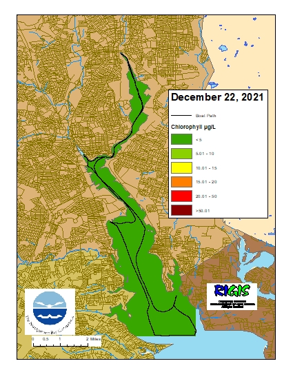
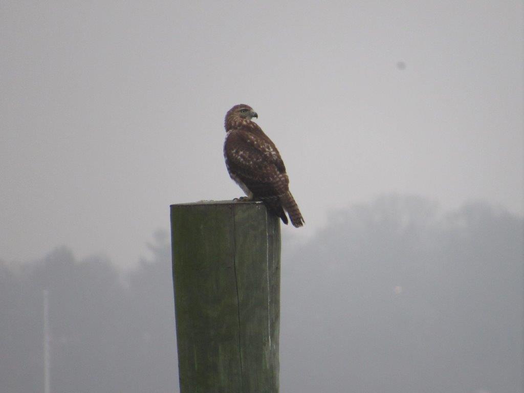
On Wednesday, December 22nd, the crew of the R/V Monitor was out on the upper Bay collecting bacteria samples, taking Secchi Disk water clarity measurements, and conducting real-time surface mapping of water quality parameters, including dissolved oxygen, chlorophyll, water temperature, salinity, and pH, all in an effort to document water quality improvements associated with NBC construction projects. Jeff captained the boat while monitoring professionals Jeffrey and Tyler collected the samples and data. It was a cold, cloudy and rainy day with little to no wind and calm waters. The featured photo shows a red tailed hawk resting on a piling in the upper Bay.
Surface Mapping
Data
were collected on December 22, 2021, while the R/V Monitor was underway
collecting bacteria samples in the Seekonk and Providence River estuaries. The average
chlorophyll concentrations were good in the areas surveyed. From north to
south, average chlorophyll concentrations were as follows: Seekonk River (1.18 µg/L),
Upper Providence River (1.27 µg/L), Edgewood Shoals area (1.26 µg/L), Pawtuxet
River area (0.61 µg/L), and Lower Providence River (0.76 µg/L). Overall,
chlorophyll ranged between 0.41 µg/L and 3.35 µg/L with an overall average of 1.09
µg/L. The chlorophyll data from this date are presented in the map below: