Historical News
R/V Monitor's Blog
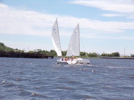
On Wednesday, June 21st, the crew of the R/V Monitor was out on the upper Bay collecting nutrients and plankton samples, taking Secchi Disk water clarity measurements, conducting water column profiles using the Seabird instrument, and conducting real-time surface mapping of water quality parameters, including dissolved oxygen, chlorophyll, water temperature, salinity, and pH, all in an effort to document water quality improvements associated with NBC construction projects. Sara captained the boat, while monitoring professionals Michael, Fern and Stephen collected the samples and data. The day was partly cloudy and breezy, with choppy waters. The below photo was taken of some sailboaters enjoying the fine weather at India Point Park.
Benthic Video Blog
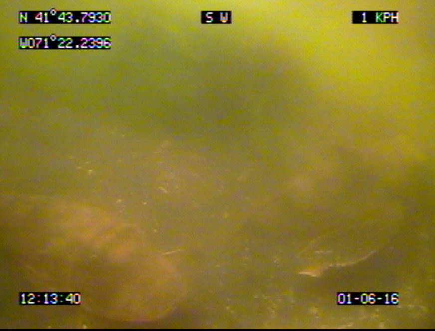
The boat crew conducted a benthic video survey along the Edgewood transect on June 27th. Visibility was poor on this survey, and only 26 minutes of footage was collected. The benthos along this transect is muddy, with numerous mudsnails (Ilyanassa sp) and mantis shrimp burrow openings. No spider crabs (Libinia emarginata) or horseshoe crabs (Limulus polyphemus) were observed, nor were there any areas of amphipod tube mats noted. There were many areas of Ulva growth or accumulation, as well as several red algae species observed. As in other surveys earlier in the spring, a number of what appear to be small white egg sacks attached to the sediment surface were observed. Ctenophore comb jellies were also abundant in the water column just above the sediment. No fish were observed in this survey, though clouds of sediment observed may have been due to fish movement away from the camera.
Benthic video transect surveys were also conducted later in June and October, as well as early 2017, though analysis is ongoing.
Surface Mapping
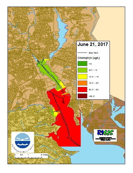
Data was collected on June 21, 2017 while the R/V Monitor was underway collecting nutrient samples and performing vertical profiles in the Providence River estuary. The chlorophyll concentrations ranged from fair to poor with a strong demarcation in concentration at the Edgewood Shoals area. The lowest average chlorophyll concentrations were observed in the Upper Providence River (17.81 µg/l) and Pawtuxet River area (13.05 µg/l). The highest average concentrations were seen in the Edgewood Shoals area (34.68 µg/l) and the Lower Providence River (33.63 µg/l) . Overall, chlorophyll ranged between 2.4 and 52.7 µg/l with an overall average of 25.24 µg/l. The chlorophyll data from this date is presented in the map below:
Benthic Video Blog
Boat crews conducted benthic video surveys along the Bullock Reach and Sabin transects on June 1st. Visibility on the surveys was moderate to poor, obscuring some fine detail on the sediment surface. Approximately 19 minutes of footage was collected at Bullock Reach, a relatively short duration video due to large patches of algae (Ulva spp) obscuring the camera during much of the footage. A longer duration video of 54 minutes was filmed along the Sabin transect. The bottom at both of these areas is soft sediment sands and mud, with extensive clam shell rubble at Sabin. The Sabin transect also features several boulders and boulder fields, with bright orange sponges growing on the hard substrate. Along both transects, clam and worm holes were frequently visible at the sediment surface, as were larger (>1 cm openings) burrows likely from mantis shrimp. We observed numerous spider crabs (Libinia emarginata) and mudsnails (Ilyanassa sp) in both transects. Other noteworthy observations included two fish species: a pair of sea robins (Prionotus carolinus; photo below) and a summer flounder (Paralichthys dentatus), both observed at Bullock Reach. Also at Bullock Reach, we observed a number of what appear to be small white egg sacks attached to the sediment surface. The same egg sacks were observed, though fewer in number, along the Sabin transect on June 1st, and at Edgewood during the last survey at that site (May 10th). These egg sacks have been observed in videos during the spring since video surveys began. Lastly, ctenophore comb jellies have also been observed frequently in the videos both this month and last month. Although this video method is not appropriate for quantitative surveys of ctenophores, they are occasionally visible in the water column just above the sediment.
Benthic video transect surveys were also conducted later in June and October, as well as early 2017, though analysis is ongoing.
Fixed Site Network
Phillipsdale
At Phillipsdale, sonde data revealed good conditions over the week some slight stratification observed. There was a 2.23 inches of rainfall, with the majority of it, 2.21 inches, falling on 6/16. Surface salinity was below 5 psu for the majority of the week expect for a few days mid-week that had an increased salinity; salinity averaged 4.2 psu, with a minimum of of 1.5 psu and a maximum of 10.2 psu. Bottom salinity was affected by tidal fluctuations this week, average bottom salinity this week was 16.7psu and ranged between 2.8 psu – 27.2 psu. Some slight stratification was observed due to these salinity differences. Surface temperatures increased as compared to the previous week with an average of 22.1oc and a range of 18.6oC – 26.5oC. Bottom temperatures also increased from last week with an average of 19.0oC and ranging between 15.9oC – 23.7oC. Surface chlorophyll was increased from last week with an average of 8.6 ug/L. Dissolved oxygen (DO) for the week was good at both depths, but did decrease some throughout the week at each depth, with a few instances of hypoxia at the bottom. The surface had an average of 8.1 mg/L and ranged from 5.4 mg/l to a 10.3 mg/L. Dissolved oxygen in the bottom waters had a weekly average of 5.0 mg/l and ranged from a minimum of 2.9 mg/L to a maximum of 9.9 mg/L. There were no extended periods of hypoxia at the bottom, just a few instantaneous readings of DO at 2.9 mg/L. Note that tidal fluctuations greatly influence bottom DO, temperature and salinity at this location.
Bullocks Reach
Water quality equipment was deployed successfully at the buoy on May 30th, though communications were lost with the buoy on May 31st. On June 5th all Hydrocat Seabird equipment was removed in addition to the communications can and solar array from the buoy. It was found that the modem responsible for communications had failed. A new modem will be installed shortly. Data loss did not occur as a second set of internally logging backup instruments are currently deployed as well.
