Week of May 6 - 12, 2018
Water Column Profiles
Water column profiles were measured at eight sites in the Providence and Seekonk Rivers on May 9, 2018. Rainfall over the five days prior to the survey was light, with 0.15 inches recorded on May 6. Stratification was observed at most sites, with warmer and fresher water at the surface and cooler, saline waters at depth. Surface temperatures ranged from 15°C at India Point Park, to 18°C at Phillipsdale Landing, Pawtuxet Cove, and Edgewood Yacht Club. Temperatures at depth ranged from 8°C at Bullock Reach, Conimicut Point, and India Point Park, to 13°C at Pomham Rocks, Pawtuxet Cove, and Edgewood Yacht Club. Surface salinity ranged from 2 PSU at Phillipsdale Landing and Pawtuxet Cove, to 20 PSU at Conimicut Point. Salinity at depth ranged from 24 PSU at Pawtuxet Cove and Pomham Rocks, to 30 PSU at Bullock Reach and Conimicut Point.
Oxygen levels were high this week and hypoxic conditions were not observed. DO concentrations ranged from 5.8 mg/L to 15.5 mg/L. Lastly, the maximum fluorescence, 26 mg/m3, was observed at a depth of 2 meters at Edgewood Yacht Club and Pomham Rocks.
Week of May 13 - 19. 2018
Surface Mapping
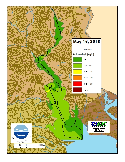
Data was collected on May 16, 2018 while the R/V Monitor was underway collecting bacteria samples and performing vertical profiles in the Providence and Seekonk River estuaries. The chlorophyll concentrations were good to fair in areas surveyed with evidence of a slight north-south gradient. From north to south, average chlorophyll concentrations were as follows: Seekonk River (3.58 µg/l), Upper Providence River (5.08 µg/l), Edgewood Shoals area (7.79 µg/l), Pawtuxet River area (5.19 µg/l), and the Lower Providence River (6.41 µg/l). Overall, chlorophyll ranged between non-detectable and 12.20 µg/l with an overall average of 5.28 µg/l. The chlorophyll data from this date is presented in the map below:
Week of May 13 - 19, 2018
R/V Monitor's Blog
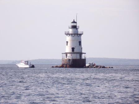
On Wednesday, May 16th, the crew of the R/V Monitor was out on the upper Bay collecting bacteria samples, taking Secchi Disk and Par sensor water clarity measurements, conducting water column profiles using the Seabird instrument, and conducting real-time surface mapping of water quality parameters, including dissolved oxygen, chlorophyll, water temperature, salinity, and pH, all in an effort to document water quality improvements associated with NBC construction projects. It was a partly cloudy day with a breeze out of the west, and a couple of brief showers occurred in the morning. The water was fairly calm this day, but mucky as a result of the rain the prior evening. The photo shown below was taken at the Conimicut Point Lighthouse, where a fisherman was enjoying the day.
Week of April 29 - May 5, 2018
Water Column Profiles
Water column profiles were measured at eight sites in the Providence and Seekonk Rivers on May 2, 2018. Rainfall five days prior to the survey totaled 0.67 inches, and additional trace amounts were recorded in the days leading up to May 2. Stratification was observed at most sites, with warmer and fresher water at the surface and cooler, saline waters at depth. Surface temperatures ranged from 11°C (India Point Park and Conimicut Point) to 14-15°C (Pawtuxet Cove and Point St. Bridge). Temperatures at depth ranged from 7°C (India Point Park) to 11°C (Pawtuxet Cove). Surface salinity ranged from <5 PSU (Pawtuxet Cove) to 23 PSU (Bullock Reach). Salinity at depth ranged from 23 PSU (Pawtuxet Cove and Phillipsdale Landing) to 29 PSU (Pomham Rocks, India Point Park, Conimicut Point, and Bullock Reach).
Oxygen levels were high this week and no hypoxic readings were measured. Dissolved oxygen concentrations ranged from approximately 6 mg/L to 11 mg/L. Lastly, the maximum fluorescence, 9.7 mg/m3, was observed at a depth of 4 meters at Bullock Reach.
Week of May 6 – May 12, 2018
Bacteria Sampling
Twenty stations were sampled for fecal coliform bacteria in the Providence and Seekonk Rivers on May 9, 2018. A total of 0.15 inches of rain occurred during the five days prior to sampling.
Overall, the fecal coliform geometric mean was 67 MPN/100 mL for both rivers, an increase from the previous sample date. The fecal coliform geomean was higher in the Seekonk River (110 MPN/100 mL) compared to the Providence River (54 MPN/100 mL). The maximum fecal coliform concentration (930 MPN/100mL) was measured at Point Street Bridge in the Providence River. Fecal coliform concentration results for both rivers were above state guidelines for shellfishing and primary contact.
The Enterococci geometric mean for the Seekonk and Providence Rivers was 10 MPN/100 mL, a slight decrease from the previous sampling date. Enterococci concentrations ranged from below detection at three stations to 10 MPN/100 mL at the Point Street Bridge and Conimicut Point stations. These results are within the state criteria for primary contact.
Please note: the results of NBC's fecal coliform and Enterococci monitoring are for informational/research purposes only and are not intended to suggest official state compliance with bathing or shellfishing standards.

