Historical News
Surface Mapping
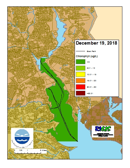
Data was collected on December 19, 2018 while the R/V Monitor was underway collecting nutrient samples and performing vertical profiles in the Providence River estuary. The chlorophyll concentrations were low in areas surveyed. From north to south, average chlorophyll concentrations were as follows: Upper Providence River (1.78 µg/l), Edgewood Shoals area (2.42 µg/l), Pawtuxet River area (2.20 µg/l), and the Lower Providence River (1.60 µg/l). Overall, chlorophyll ranged between 0.60 µg/l and 4.30 µg/l with an overall average of 2.03 µg/l. The chlorophyll data from this date is presented in the map below:
Nutrients Sampling
Among the river stations sampled, highest total nitrogen (TN), total dissolved nitrogen (TDN), and dissolved inorganic nitrogen (DIN) values were measured in the Ten Mile River at Central Avenue, with reported values of 1250 ppb, 1180 ppb, and 853 ppb, respectively. The Woonasquatucket River at Valley Street had the lowest measured TN (503 ppb) and TDN (589 ppb) values. Lowest DIN concentrations were observed in the Palmer River at Route 6, at 82 ppb.
Highest bay surface nutrient concentrations occurred at Pawtuxet Cove, with TN, TDN, and DIN concentrations of 928 ppb, 896 ppb, and 624 ppb, respectively. Edgewood Shoals demonstrated the lowest nitrogen values, at 547 ppb TN, 508 ppb TDN, and 362 ppb DIN. Chlorophyll a averaged 0.6 ug/L, ranging from <0.3 ug/L at Conimicut Point to 1.3 ug/L at Phillipsdale Landing.
Results from nutrient sampling completed on November 21 and December 5 are pending final analysis from the NBC Laboratory. The next anticipated date of sampling is December 19, 2018.
Benthic Video Blog
Benthic Video Blog
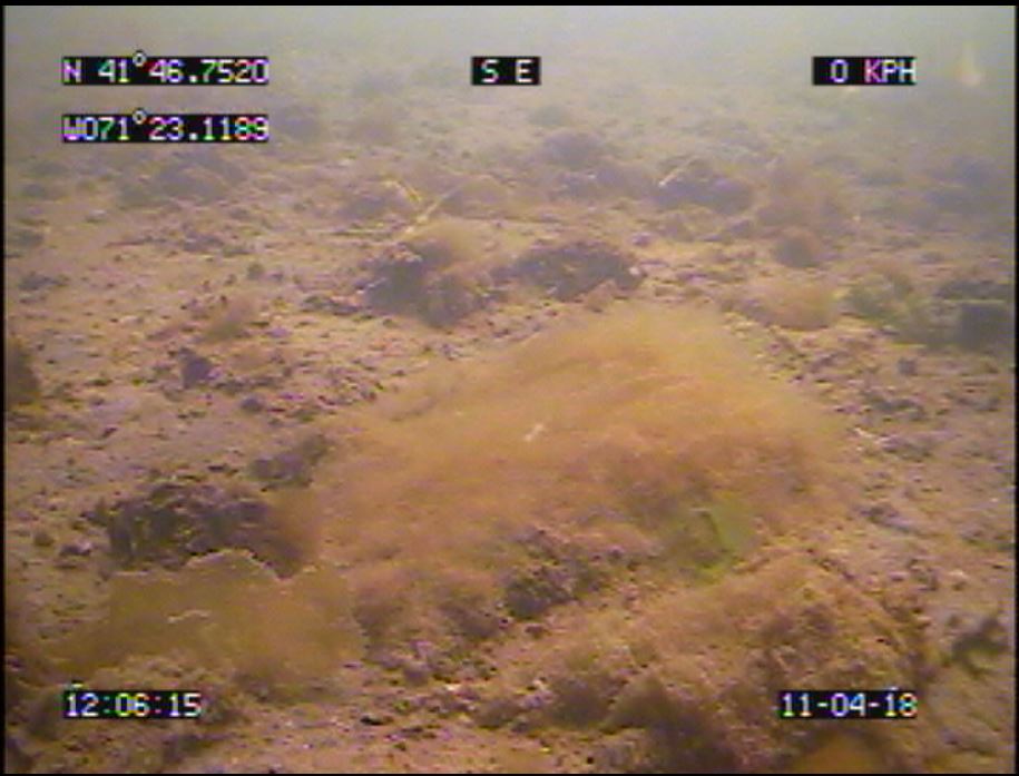
The boat crew conducted a benthic video survey along the Edgewood transect on April 11th. Scale lasers were used in the footage, separated by 28 cm. Visibility through the water column was moderate to good. The bottom was characterized by sands and muds, with a few boulders and cobbles observed sporadically. There was some bushy growth of diatoms or a filamentous brown alga (see photo) throughout the transect, though coverage was never extensive. The unknown brown sheet-like alga observed last month along the Sabin transect was also observed at Edgewood on this date. Additional common sights included large burrows, likely from mantis shrimp (Squilla); many small burrows and associated fecal mounds; and occasional Nassariid mudsnails. Amphipod tube mats were not observed.
Benthic Video Blog
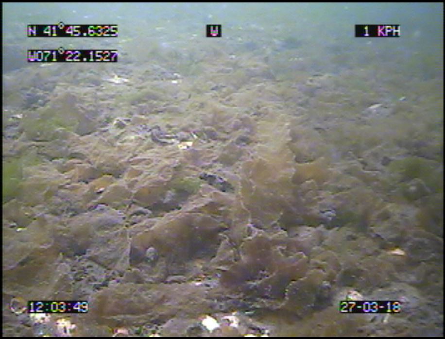
The boat crew conducted a benthic video survey along the Sabin transect on March 27th. Unfortunately, one of the scale lasers failed during deployment, so only one beam was visible in footage. Visibility through the water column was good, and interesting observations were made. The bottom was characterized by muddy sand with some areas of extensive shell hash and rubble. Some boulders were observed, but the boat missed the main boulder field often observed along this transect. There was a lot of bushy algae or diatom growth observed, typical for the early spring, as well as small patches or rafts of Ulva. Extensive areas of an unknown brown sheet-like alga (see photo) were observed. As usual, some litter was also observed along the transect. Additional common sights included small burrows and tubes built by infauna (e.g., parchment tube worms, Chaetopteridae) and dense assemblages of Nassariid mudsnails. Dense areas of amphipod tube mats and Beggiatoa bacteria growth were not observed this week.