Historical News
Water Column Clarity
Water clarity was measured at nine locations in the Providence and Seekonk Rivers on October 31, 2018. Approximately 2 inches of precipitation was recorded in the five days prior to sampling. However, no rainfall was recorded on the day prior to nor the day of sampling. Overall, average water clarity decreased from the previous week, from 2.7 m to 1.9 m. Decreases in water clarity were observed at Pomham Rocks and Edgewood Yacht Club, while water clarity increased at Bullock Reach and Conimicut Point. Secchi depth ranged from 1.03 m at Pawtuxet Cove to 3.23 m at Bullock Reach and Conimicut Point. There was slight evidence of a north to south water clarity gradient.
Bacteria Sampling
Twenty stations were sampled for fecal coliform bacteria in the Providence and Seekonk Rivers on October 31, 2018; five of these stations were also sampled for enterococci bacteria. In the five days prior to sampling, nearly 2 inches of rainfall was recorded, with the majority of precipitation (1.81 in) occurring four days prior to sampling.
Fecal coliform geometric mean increased from the previous sampling to 120 MPN/100 mL. Fecal coliform concentrations were higher in the Providence River (geometric mean: 130 MPN/100 mL) than in the Seekonk River (geometric mean: 101 MPN/100 mL). The highest Seekonk River fecal coliform value, 230 MPN/100 mL, was measured at Crook Point. In the Providence River, the maximum fecal coliform concentration of 430 MPN/100 mL was measured at both the Save the Bay and South F.P. East locations. Geometric mean results indicate both rivers exceeded primary contact and shellfishing standards.
The overall enterococci geometric mean was 107 MPN/100 mL. Concentrations ranged from approximately 88 MPN/100 mL at Conimicut Point (geometric mean of two duplicates) to 156 MPN/100 mL at South F.P. East. Bridge. The geometric mean of all results exceeded the state primary contact standard.
Please note: the results of NBC's fecal coliform and enterococci monitoring are for informational/research purposes only and are not intended to suggest official state compliance with bathing or shellfishing standards.
Water Column Profiles
Water column profiles were measured at nine sites in the Seekonk and Providence Rivers on October 31, 2018. Approximately 2 inches of rainfall was recorded in the five days before sampling, with the majority of the rainfall (1.81 in) occurring four days prior to sampling. Most sites were relatively well-mixed, though some stratification was observed in the Seekonk and Upper Providence River sites, including Phillipsdale Landing, India Point Park, Point Street Bridge, and Edgewood Shoal.
Salinity in surface waters ranged from 5 psu at Phillipsdale Landing to 26 psu at India Point Park. Salinity at depth ranged from 12 psu at Pawtuxet Cove to 30 psu at Conimicut Point. Highest water column temperatures were observed at Point Street Bridge, ranging from 14.7°C at the bottom to 15.3°C in the surface waters. Lowest water temperatures were observed at the surface at Phillipsdale Landing (9.5°C) and at depth at Pawtuxet Cove (11.9°C).
Hypoxic conditions (dissolved oxygen <2.9 mg/L) were not present at any of the nine sites sampled. The maximum dissolved oxygen (DO) concentration (10.14 mg/L) was observed at a depth of 1.5 m at Conimicut Point, while the minimum DO concentration (4.06 mg/L) occurred in the bottom waters near Edgewood Yacht Club. Fluorescence was generally low, with <4 mg/m3 observed at all sites.
R/V Monitor's Blog
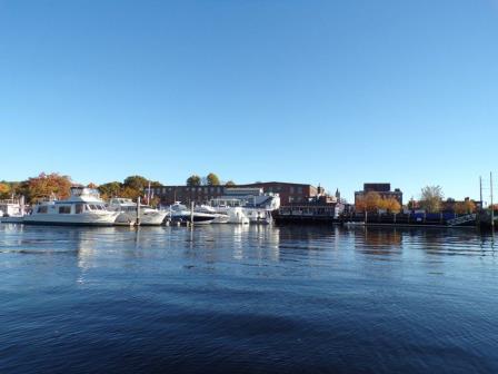
On Wednesday, October 31st, the crew of the R/V Monitor was out on the upper Bay collecting bacteria samples, taking Secchi Disk and Par sensor water clarity measurements, conducting water column profiles using the Seabird instrument, and conducting real-time surface mapping of water quality parameters, including dissolved oxygen, chlorophyll, water temperature, salinity, and pH, all in an effort to document water quality improvements associated with NBC construction projects. Sara captained the boat while monitoring professionals Mike, Mike and Amanda collected the samples and data. In addition, staff serviced the Seekonk River temporary fixed monitoring site equipment this day. The day started off sunny with no wind and calm waters. By the afternoon, a wind out of the southeast made the waters quite choppy. The photo taken this day features the Fox Point Marina.
Water Column Profiles
Hypoxic conditions (dissolved oxygen <2.9 mg/L) were not present at any of the four sites sampled. The maximum dissolved oxygen (DO) concentration, 7.73 mg/L, was observed in surface waters at Conimicut Point, while the minimum DO concentration, 4.99 mg/L, occurred at depth at Pomham Rocks. The maximum fluorescence, 3.03 mg/m3, was observed at a depth of 3 m at Bullock Reach.

