Historical News
Water Column Clarity
Water clarity was measured with a Secchi disk at seven locations in the Providence River Estuary on June 7, 2017 after significant rainfall. 1.34 inches of rain fell during the five days prior to sampling. Secchi depth ranged from 1.6 meters at Pawtuxet Cove to 2.6 meters at both Bullock Reach and Conimicut Point. The water in the Providence River Estuary was slightly clearer compared to the previous sampling on June 1st, with an overall average of 2.2 m. The largest increase of 1.3 m was observed at the Edgewood Yacht Club site. A slight north to south water clarity gradient was apparent, with the greatest water clarity observed at the southern end of the estuary.
Water Column Profiles
Eight water column profiles were measured in the Providence River estuary on June 7, 2017. The three days leading up to the survey were rainy, dropping a total of 0.81 inches of precipitation. Sites near river inputs displayed stratified conditions, with fresh, high-oxygen surface waters over more saline bottom waters with decreased dissolved oxygen (DO). For example, Pawtuxet Cove surface waters had salinities of 8-10 psu and DO concentrations of 6-8 mg/L; in comparison, bottom waters at this site measured 28 psu and 4.8 mg/L. At Phillipsdale Landing, surface waters had salinities of 5-7 psu and DO concentrations of 9.0 mg/L; bottom waters at this site measured 26 psu and 3.8 mg/L. The surface waters at Phillipsdale Landing were also the warmest observed on this survey date, at 16°C, slightly cooler than temperatures observed the previous week.
The remaining sites, which have less riverine influence, displayed only weak stratification. Surface salinities were generally high, 22-29 psu; bottom waters displayed a maximum salinity of 31.1 psu at Conimicut Point. These were also the coolest waters, at 13.7°C, though this was similar to most surface waters which were generally around 14.5°C. Dissolved oxygen levels at all locations remained above the hypoxia threshold of 2.9 mg/L, ranging from 3.8 mg/L in the bottom waters of Phillipsdale Landing, as noted above, to 9.0 mg/L in the surface waters of that site. Most other sites exhibited DO concentrations of 4.8-6.8 mg/L. Fluorescence was slightly decreased from the previous week, with maximum values of 6-7 mg/m3 observed around the 3.5 m depth at Conimicut Point and Bullock Reach.
Water Column Profiles
Eight water column profiles were measured in the Providence River estuary on June 1, 2017. A total of 0.28 inches of rain fell over the three days leading up to sampling, with additional trace rainfall recorded the morning of the survey. Moderate stratification was observed at survey locations, particularly at sites nearest river inputs. Two of these sites, Pawtuxet Cove and Phillipsdale Landing, displayed low salinity surface waters 5-10 psu. Bottom waters at these locations were more saline, ranging 20-25 psu. A third site with riverine influence, Point St. Bridge, also displayed relatively low surface salinities (e.g., <15 psu), and also the highest temperatures observed this week (19.36°C). This site is located where the Moshassuck River canal through the city enters the Providence River, and frequently displays evidence of warming as the water passes through downtown.
Among the other sites with less direct riverine influence, the freshest surface water was 14.8 psu, at the northern end of the Providence River at India Point Park. The most saline water, 29-30 psu, was found at the bottom of the deepest sites, Pomham Rocks, Conimicut Point, and Bullock Reach, indicative of the “salt wedge” tidal waters. Warm surface waters 18-19°C were observed at Pomham Rocks and Edgewood Yacht Club, while bottom waters at most sites ranged 13.8-15.2°C. Dissolved oxygen levels throughout the Providence River estuary remained above the hypoxia threshold of 2.9 mg/L, ranging from 3.4 mg/L in the bottom waters of Point St. Bridge to 11.7 mg/L at Pomham Rocks. The DO maximum at Pomham Rocks was in surface waters, where the maximum fluorescence was also observed at 29.47 mg/m3. This was a slight increase in fluorescence observed at sites compared to the previous week.
Nutrients Sampling
Fourteen river stations were sampled for nutrients on Wednesday, May 10th; seven bay stations were also sampled for nutrients at the surface and one station was sampled at the surface and bottom on this date. A total of 2.60 inches of rainfall was recorded in the Providence area in the five days leading up to the sampling event. Among the river locations, the highest total nitrogen (TN), and dissolved inorganic nitrogen (DIN) were measured at the Ten Mile River at Central Ave, with concentrations of 1,220 ppb and 736 ppb respectively; the highest total dissolved nitrogen (TDN) was measured at the Runnins River with a concentration of 1,270 ppb. The lowest TN was measured at the Blackstone River at Rt.116 Bikepath with 807 ppb TN; the lowest TDN was measured at the Blackstone River at the Stateline with 655 ppb, and the lowest DIN was measured at the Coles River location with 118 ppb for DIN. In the Bay, the highest surface concentrations of Total Nitrogen was measured at Phillipsdale Landing with 1,180 ppb for TN; at the Pawtuxet Cove the results were 812 ppb for TDN and 627 ppb DIN. The lowest surface TN concentration was measured at Pomham Rocks, at 953 ppb TN, and Conimicut Point had concentrations of 407 ppb for TDN, and 327 ppb for DIN. Chlorophyll concentrations decreased greatly from the previous nutrient sampling survey, with a maximum of 2.5 ug/L measured at Bullocks Reach and a low of 1.1 ug/L measured at Phillipsdale Landing; overall chlorophyll averaged 1.7 ug/L.
Results from nutrient sampling completed on May 24th and June 7th are pending analysis from the NBC Laboratory. The next anticipated sampling date for nutrients is June 21st.
Benthic Video Blog
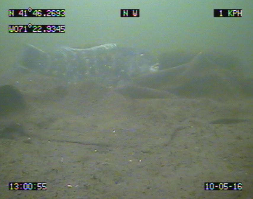
Boat crews conducted benthic video surveys along the Bullock Reach and Edgewood Yacht Club transects on May 10th. Conditions were calm and sunny, and underwater visibility was moderate. Approximately 36 minutes of footage was collected at Bullock Reach and 53 minutes at Edgewood. The bottom at both of these areas is soft sediment sands and mud, with areas of clam shell rubble and hash as well as many live Crepidula slipper snail stacks. Clam and worm holes were frequently visible at the sediment surface, as were larger (>1 cm openings) burrows likely from mantis shrimp. There were no dense mats of amphipod tubes observed, however. We observed numerous spider crabs (Libinia emarginata), channeled whelk (Busycotypus canaliculatus), and mudsnails (Ilyanassa sp) in both transects. Horseshoe crabs (Limulus polyphemus) were particularly abundant in the videos – this species typically comes to shallow water at this time of year to spawn, and several mating pairs were observed. Other noteworthy observations included two fish species: a sea robin (Prionotus carolinus) observed at Bullock Reach, and a tautog (Tautoga onitis; photo below) observed at Edgewood!
Benthic video transect surveys were also conducted in June and October, as well as early 2017, though analysis is ongoing.