Week of August 1 - 7, 2021
Water Column Clarity
Water clarity was measured at eight locations in the Providence and Seekonk River estuaries on August 4, 2021. Conditions this week were dry, with no rainfall recorded at T.F. Green over the three days prior to the survey. There was a slight decrease in water clarity since the prior week’s survey. Overall, sites averaged 1.5 meters Secchi depth, compared to 1.8 meters on July 28, 2021. The lowest clarity (0.9 meters) was measured at Edgewood Yacht Club, while the highest (2.1 meters) was measured at Conimicut Point. There was no gradient of increasing clarity from north to south this week.
Week of July 25 - 31, 2021
Nutrients Sampling
Nutrient samples were collected from seven local river stations and seven bay stations (surface and bottom) on July 28, 2021. Weather conditions leading up to the sampling day included light rainfall recorded at T.F. Green, totaling 0.24 inches over the five days prior.
Among the river stations sampled, the highest total nitrogen (TN), total dissolved nitrogen (TDN), and dissolved inorganic nitrogen (DIN) concentrations occurred at the Pawtuxet River at Broad St. site. At this site, TN, TDN, and DIN concentrations were 1,220 ppb, 1,280 ppb, and 903.7 ppb, respectively. The lowest nitrogen was measured in the sample from the Moshassuck River at Higginson Ave. at 528 ppb TN, 658 ppb TDN, and 284.4 ppb DIN.
Among the Bay station surface results, the highest TN (1,040 ppb) and DIN (634.7 ppb) occurred at Pawtuxet Cove, while the highest TDN (785 ppb) occurred at Phillipsdale Landing. The lowest surface TN (596 ppb) was observed at Conimicut Point, though a duplicate sample from this site was higher (685 ppb). The lowest TDN and DIN occurred in these duplicate samples, averaging 288 ppb and 98.6 ppb, respectively. Chlorophyll a concentration at the Bay sites increased since the previous sampling event, averaging 27.5 ug/L. The maximum result of 55.99 ug/L occurred at Bullock Reach.
Results from nutrient sampling on August 11, and August 25 are pending analysis. The next scheduled sample date is September 8.
Week of July 11 - 17, 2021
Nutrients Sampling
Nutrient samples were collected from thirteen local and border river stations on July 14, 2021. Bay sampling was conducted the following day, due to unsafe weather conditions on July 14t. Bay sampling included six sites sampled at the surface only and one site sampled at the surface and bottom. Weather conditions leading up to the sampling days included substantial rainfall on July 9 (2.05 inches) and more moderate rain on July 12 (0.63 inches), as recorded at T.F. Green.
Among the river stations sampled, the highest total nitrogen (TN) and total dissolved nitrogen (TDN) concentrations were from the Warren Reservoir/Kickemuit River site. At this site, TN and TDN concentrations were 1,260 ppb and 1,350 ppb, respectively. The highest dissolved inorganic nitrogen (DIN) concentration (438.5 ppb) was measured in the sample from the Moshassuck River at Footbridge at Mill St. The lowest TN (571 ppb) occurred at the Woonasquatucket River at Manton Ave. Bridge. The lowest TDN (583 ppb) occurred at the Blackstone River at Stateline. The lowest DIN (93.6 ppb) occurred at the Palmer River at Route 6.
Among the Bay station surface results, the highest surface TN (820.5 ppb) and DIN (465.1 ppb) occurred at Pawtuxet Cove (average of duplicates), while the highest TDN (841 ppb) occurred at Phillipsdale Landing. The lowest surface TN (700 ppb) was observed at Pomham Rocks, while the lowest TDN (519 ppb) and DIN (277.4 ppb) occurred at Conimicut Point. Chlorophyll a concentration at the Bay sites decreased since the previous sampling event, averaging 1.13 ug/L across all sites. The maximum result of 4.76 ug/L occurred at Conimicut Point.
Results from nutrient sampling on July 28, August 11, and August 25 are pending analysis. The next scheduled sample date is September 8.
Week of August 22 - 28, 2021
R/V Monitor's Blog
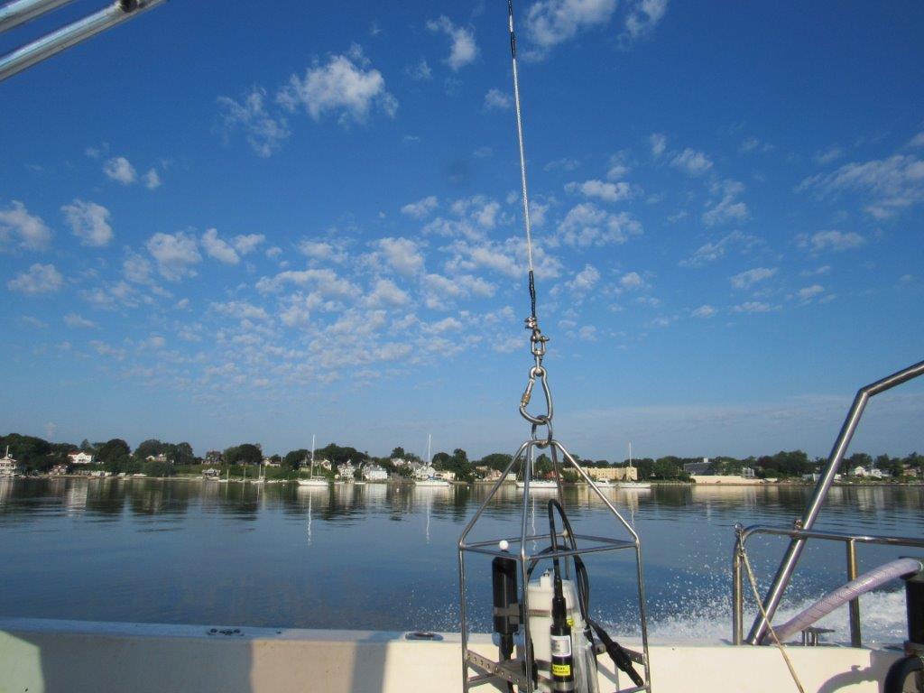
On Wednesday, August 25th, the crew of the R/V Monitor was out on the upper Bay collecting nutrients and plankton samples, taking Secchi Disk and Par sensor water clarity measurements, conducting water column profiles using the Seabird instrument, and conducting real-time surface mapping of water quality parameters, including dissolved oxygen, chlorophyll, water temperature, salinity, and pH, all in an effort to document water quality improvements associated with NBC construction projects. Jeff captained the boat while monitoring professionals Amanda, Jeff, and summer intern Mackenzie collected the samples and data. It was a sunny, hazy, hot and humid day with no wind early on but a light breeze developed from the southwest as the day progressed. The water was extremely calm all day. The photo below was taken at Edgewood Yacht Club and shows the NBC's Seabird water column profiling instrument in the foreground.
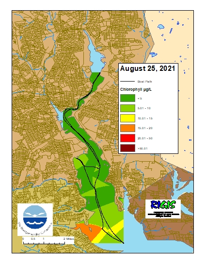
Week of August 22 – August 28, 2021
Surface Mapping
Data
were collected on August 25, 2021, while the R/V Monitor was underway
collecting nutrient samples in the Seekonk and Providence River estuaries. The average
chlorophyll concentrations were good to fair in the areas surveyed. From north
to south, average chlorophyll concentrations were as follows: Seekonk River (3.25
µg/L), Upper Providence River (4.20 µg/L), Edgewood Shoals area (5.63 µg/L), Pawtuxet
River area (4.64 µg/L), and Lower Providence River (12.73 µg/L). Overall,
chlorophyll ranged between 2.11 µg/L and 19.62 µg/L with an overall average of 7.34
µg/L. The chlorophyll data from this date are presented in the map below: